


Les efforts de lutte contre les changements climatiques se reflètent dans les responsabilités des MRC par différents outils de planification et leviers en matière de protection de l'environnement.
Plan climat

À l'hiver 2025, la MRC a débuté l'élaboration de son plan climat qui ultimement identifiera les projets prioritaires pour réduire les émissions de gaz à effet de serre (GES), s’adapter aux changements climatiques et soutenir la transition climatique.
Pourquoi un plan climat?
Cet outil, élaboré grâce à une démarche participative, aidera d’abord à mieux comprendre les effets des changements climatiques en procédant à l’inventaire des émissions de GES générées par les activités locales et en analysant les risques climatiques et les vulnérabilités présents sur le territoire.
Riche de ces connaissances, un plan d’action sera élaboré pour être en mesure de poser des gestes concrets adaptés à la réalité du territoire et ainsi accroître la résilience des communautés locales face aux changements climatiques.
Deux volets guident l’élaboration du plan climat :
- Adaptation : réagir à l’impact des changements climatiques en établissant des mesures visant à diminuer les répercussions occasionnées par les aléas climatiques ;
- Atténuation : agir sur les causes des changements climatiques en réduisant les émissions de GES qui en sont responsables.
Comprendre les changements climatiques
Comment les changements climatiques affecteront-ils le Québec dans les prochaines années? | Qu'est-ce que ça veut dire : s'adapter aux changements climatiques? | Comment la science fait-elle pour représenter le climat futur ? |
Capsules vidéo produites par Ouranos
Les travaux de réalisation du Plan climat se sont enclenchés à l'automne 2024, en vue d'une approbation finale en 2027. Cette démarche est financée dans le cadre du programme Accélérer la transition climatique locale (ATCL) et découle du Plan pour une économie verte 2030.
Avec la participation financière du
Plan régional des milieux humides et hydriques (PRMHH)
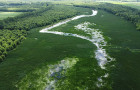
En 2017, le gouvernement du Québec a confié aux municipalités régionales de comté (MRC) la tâche d’élaborer un plan régional des milieux humides et hydriques (PRMHH). Ce document de réflexion stratégique, encadré par la Loi affirmant le caractère collectif des ressources en eau et favorisant une meilleure gouvernance de l’eau et des milieux associés a pour objectif d’« intégrer la conservation des milieux humides et hydriques (MHH) à la planification du territoire, en favorisant un développement durable et structurant (MELCCFP, 2021) ».
L’objectif du PRMHH est de mettre en place un outil de planification qui permette d'orienter les décisions en matière de conservation et d'utilisation durable des MHH sur le territoire de la MRC du Haut-Richelieu.
La MRC est en attente de l'approbation du ministère de l'Environnement, de la Lutte contre les changements climatiques, de la Faune et des Parcs pour son entrée en vigueur.
Délimitation du domaine hydrique de l'État (ligne hydrique)
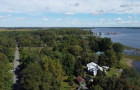
Le 26 mars 2002, le ministre de l’Environnement a conclu un protocole d’entente avec la MRC du Haut-Richelieu concernant la délimitation du domaine hydrique de l’État et la gestion de la plaine inondable de la rivière Richelieu et de la baie Missisquoi du lac Champlain. Dans le cadre de ce protocole, les parties convenaient dans un premier temps de produire une cartographie détaillée du territoire en vue d’obtenir un portrait fidèle et à jour de la rivière et de la plaine inondable.
Sur la base de cette cartographie et des renseignements recueillis, les parties convenaient de proposer des solutions sur :
- La régularisation des titres de propriété dans certains secteurs ;
- La protection écologique du milieu ;
- L'aménagement et l'utilisation appropriée des plans d’eau et de la plaine inondable de la rivière Richelieu et de la baie Missisquoi.
Entre 2002 et 2009, le ministère du Développement Durable, de l'Environnement et des Parcs (MDDEP) a réalisé plusieurs travaux devant mener à la production de nouvelles cartes soit :
- relevés terrain;
- traçage et validation de cotes de crue de récurrence de 2 ans, 20 ans et 100 ans;
- étude des milieux naturels d’intérêt pour la conservation et la consultation des intervenants;
- examen détaillé des droits déjà consentis sur le domaine hydrique de l’État;
- inventaire des constructions et des remblais en zone inondable postérieur à 1978.
À cet effet, le gouvernement du Québec a adopté en 2009 la Loi visant à délimiter le domaine hydrique de l'État et à protéger les milieux humides le long d'une partie de la rivière Richelieu. Cette loi permet de protéger de façon permanente 865 hectares de milieux humides de propriété qui comptent parmi les plus riches sur le plan de la biodiversité. Il clarifie les titres de propriété d'environ 1 300 riverains de cette partie de la rivière Richelieu.
Pour en savoir plus
Zones inondables
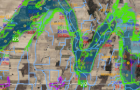
Les zones inondables sont des étendues de terre susceptibles d'être submergées lors des crues printanières ou d'autres événements hydrologiques. Dans le Haut-Richelieu, elles se situent principalement dans le bassin de la rivière Richelieu et du lac Champlain.
La carte interactive illustrant les zones à risque d'inondation permet aux citoyens et aux visiteurs de mieux comprendre les risques et les effets de la réglementation en vigueur. Elle est générée en fonction des informations issues de la Base de données des zones à risque d'inondation (BDZI) du ministère de l'Environnement, de la Lutte contre les changements climatiques, de la Faune et des Parcs (MELCCFP).
Le gouvernement du Québec procède actuellement à une modernisation du cadre réglementaire en milieux hydriques, lequel prévoit la mise à jour de la cartographie des zones inondables pour le bassin versant de la rivière Richelieu, le bassin versant de la rivière Yamaska et le bassin versant de la baie Missisquoi. La nouvelle cartographie pour le Haut-Richelieu sera publiée après 2026.
Interventions dans les zones à risque d'inondation
Depuis le 1er mars 2022, c'est le Règlement concernant la mise en œuvre provisoire des modifications apportées par le chapitre 7 des lois de 2021 en matière de gestion des risques liés aux inondations qui encadre les activités (travaux, constructions ou autres interventions) réalisées dans les rives, le littoral et les zones inondables.
Reddition de comptes
Les municipalités doivent tenir un registre des autorisations délivrées en vertu du régime transitoire et transmettre à la MRC, au plus tard le 31 janvier de chaque année, les informations portant sur ces autorisations.
Chaque MRC doit publier le bilan annuel des autorisations délivrées par les municipalités de son territoire, le 31 mars de chaque année. En vertu du régime transitoire, ce bilan doit notamment préciser le nombre d’autorisations délivrées par municipalité, la liste des différentes activités autorisées et la superficie totale (en mètre carré) visée par l’ensemble des autorisations délivrées.
Bilan annuel 2024 - Régime transitoire
Commission mixte internationale (CMI)
En 2016, les gouvernements des États-Unis et du Canada ont demandé à la Commission mixte internationale (CMI) d’étudier la question des inondations dans le bassin versant du lac Champlain et de la rivière Richelieu (LCRR) afin d’en déterminer les causes, les répercussions et les risques et de dégager d’éventuelles solutions pour atténuer ce problème. Les gouvernements ont demandé à la CMI de s’appuyer sur les travaux qu’elle avait effectués en 2015 et d’orienter ses nouveaux efforts vers la mise en œuvre des activités [suivantes]:
- Comprendre les causes et les répercussions des crues antérieures;
- Évaluer les possibilités offertes par les pratiques exemplaires de gestion des plaines inondables;
- Travailler à l’élaboration d’un système binational de prévision des crues et de cartographie des plaines inondables en temps réel;
- Dégager les mesures d’atténuation structurelles et non structurelles les plus prometteuses;
- Comprendre les perceptions sociales et politiques des mesures structurelles et autres mesures d’atténuation proposées;
- Comprendre l’impact de la gestion des inondations et de différentes mesures d’atténuation sur les écosystèmes, l’utilisation de l’eau, l’environnement bâti et l’agriculture (au moyen d’un outil de visualisation et de prise de décisions).
Source : Brochure
Autres études pertinentes
Étude hydrologique et hydraulique - WSP, 2017
Étude hydrologique et hydraulique - Erratum - WSP, 2018
En savoir plus
Fonds pour la protection de la rivière Richelieu et des milieux humides associés
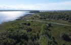
Le Fonds pour la protection, la restauration et la mise en valeur de la rivière Richelieu et des milieux humides associés est institué par la MRC du Haut-Richelieu et affecté au financement de mesures prises par les municipalités locales d'Henryville, Lacolle, Noyan, Saint-Blaise-sur-Richelieu, Saint-Jean-sur-Richelieu, Saint-Paul-de-l'Île-aux-Noix et Sainte-Anne-de-Sabrevois aux fins de promouvoir la protection, la restauration et la mise en valeur de la partie de la rivière Richelieu visée par la Loi concernant la délimitation du domaine hydrique de l'État et la protection des milieux humides le long d'une partie de la rivière Richelieu, ainsi que des milieux humides qui lui sont associés dont ses rives et sa plaine inondable (P.L. 28 adopté le 18 juin 2009).
La constitution de ce Fonds vise le respect des articles 20 à 28 de la Loi concernant la délimitation du domaine hydrique de l'État et la protection des milieux humides le long d'une partie de la rivière Richelieu adoptée le 18 juin 2009 et sanctionnée le 19 juin 2009.
Projets financés
- Projet d'aménagement du site du Quai Ryan à Sainte-Anne-de-Sabrevois
- Programme décennal de dragage des canaux à Saint-Paul-de-l'Île-aux-Noix
- Espace de liberté des ruisseaux Hazen-Bleury et de la Barbotte à Saint-Jean-sur-Richelieu
- Acquisition d'un terrain et création d'un refuge pour la faune et la flore à Saint-Jean-sur-Richelieu
